Aerial Infrared Surveys for Pollution and Sewer Leak Detection: A Proactive Approach
In an era where environmental sustainability and operational efficiency are paramount, aerial infrared surveys have emerged as a powerful tool for detecting pollution and sewer leaks. By using cutting-edge technology to identify potential issues before they escalate, organizations can mitigate environmental hazards and optimize maintenance strategies. This comprehensive guide explores the role of aerial infrared surveys in proactive environmental management, emphasizing their cost-effectiveness and practical applications in various industries.
Understanding Aerial Infrared Surveys
Aerial infrared surveys are conducted using specialized aircraft equipped with infrared sensors. These sensors capture thermal images that reveal temperature variations on the ground. Such variations can indicate underlying issues like sewer leaks, pollution hotspots, or inefficient energy usage. Unlike traditional inspection methods, aerial infrared surveys provide a broad overview of large areas, making them ideal for extensive facilities and infrastructure.
With over 37 years of experience, AIT Scan specializes in aircraft-based infrared scanning. This method is especially advantageous for large-scale projects, offering comprehensive coverage and detailed data that smaller drones may not achieve. For more on the technology behind these surveys, visit AIT Scan’s thermal mapping page.
The Cost-Effectiveness of Aerial Infrared Surveys
The cost-effectiveness of aerial infrared surveys lies in their ability to detect issues early, allowing for timely interventions that prevent costly damage. Traditional inspection techniques often require significant time and labor, whereas aerial infrared surveys quickly cover vast areas, identifying problems that might otherwise go unnoticed.
- Reduced Labor Costs: Fewer personnel are needed compared to ground-based inspections, resulting in lower overall inspection costs.
- Prevention of Major Failures: Early detection of leaks and pollution reduces the risk of catastrophic failures, saving on expensive repairs and potential legal liabilities.
- Efficient Resource Allocation: By pinpointing problem areas, organizations can allocate resources more effectively, focusing efforts where they are most needed.
For further insights into the financial benefits of aerial infrared surveys, refer to AIT Scan’s commercial roof moisture surveys section.
Applications in Pollution and Sewer Leak Detection
Aerial infrared surveys are particularly effective in detecting pollution and sewer leaks due to their ability to identify thermal anomalies. These anomalies often signal the presence of pollutants or leaks, offering a non-invasive means to monitor environmental health.
Pollution Detection
Thermal imaging can highlight areas of unusual heat patterns, often associated with pollution sources such as landfill fires or chemical spills. By identifying these hotspots, facility managers can take corrective actions before pollutants spread, safeguarding both the environment and public health.
Sewer Leak Detection
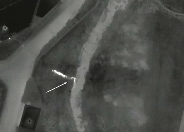
Sewer systems are prone to leaks that can cause ground subsidence and environmental contamination. Aerial infrared surveys detect subtle temperature differences that indicate leaks, enabling quick repairs. This proactive approach minimizes damage and maintains system integrity.
Explore more about these applications at AIT Scan’s pollution and sewer leak detection services.
Technical Insights into Infrared Thermography
Infrared thermography involves capturing and analyzing thermal radiation emitted by objects. In the context of environmental surveys, this technique helps visualize temperature differences that are invisible to the naked eye, providing critical insights into structural and environmental conditions.
Key technical aspects include:
- Resolution and Sensitivity: High-resolution thermal cameras detect minute temperature variations crucial for identifying leaks and pollution.
- Data Analysis: Advanced software analyzes thermal data to produce detailed reports, helping decision-makers understand and act on findings.
For a deeper dive into the technical aspects of infrared thermography, visit AIT Scan’s category page on pollution and sewer leak detection.
Comparing Inspection Methods
While aerial infrared surveys offer distinct advantages, it’s important to understand how they compare to other inspection methods like drones or handheld devices.
Aircraft vs. Drone Surveys
Drones are suitable for smaller areas and detailed inspections, but aircraft-based infrared scanning is preferred for large-scale surveys due to its higher altitude and broader coverage, reducing the need for multiple flights.
Handheld Devices
Handheld infrared devices offer precision but are labor-intensive and limited to ground-level inspections, making them impractical for large facilities.
For comprehensive roof moisture detection, consider AIT Scan’s aerial infrared scanning benefits.
Real-World Examples and Case Studies
Numerous industries have benefited from aerial infrared surveys, from universities detecting campus utility leaks to municipalities identifying pollution sources.
For instance, a recent project involved a large university campus where infrared thermography was used to detect underground steam leaks, saving the institution significant repair costs and preventing energy loss. Similarly, a municipal project utilized thermal imaging to locate and address pollutants in a local waterway, significantly improving environmental compliance.
These examples underscore the versatility and impact of aerial infrared surveys in protecting assets and the environment.
Conclusion
Aerial infrared surveys represent a proactive approach to environmental management and maintenance, offering significant cost savings and operational benefits. By utilizing advanced technology to detect pollution and sewer leaks early, organizations can safeguard their infrastructure and the environment. For those interested in leveraging these capabilities, AIT Scan’s extensive experience and nationwide reach ensure expert support for any project scale. To explore how aerial infrared surveys can benefit your organization, visit AIT Scan’s capital planning and commercial portfolios page.