Of Infrared Expertise
Plus Alaska & Puerto Rico
Not Drones
For Facility Decision-Makers
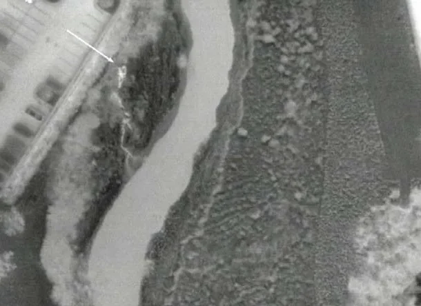
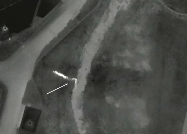
Aerial sewer leak detection uses aircraft-mounted infrared sensors to identify thermal anomalies associated with sanitary exfiltration, stormwater infiltration, illicit discharges, and outfall plumes across municipal and campus water-management networks. When water leaves or enters a system at a different temperature than the surrounding soil or receiving water, that contrast can create a detectable thermal signature.
AITscan captures and georeferences those signatures across the survey area so environmental, engineering, and utility teams can focus follow-up investigation on suspected problem locations. The resulting data can help identify outfalls that need attention, sanitary lines that may require rehabilitation, and areas where water movement is affecting the thermal profile of the system.
For municipalities managing broader infrastructure programs, CityScan IR can complement this work by providing municipal thermal mapping across multiple utility systems. AITscan’s aerial survey data can also support MS4 documentation, NPDES reporting, GIS workflows, and capital-planning decisions.
Ground-based thermography and short-range platforms can be effective for a known outfall, a short stream reach, or a localized sewer concern. For municipal watersheds, campus networks, and broader water-management programs, aircraft-based aerial sewer leak detection can provide much wider coverage within a coordinated thermal and weather window.
AITscan can survey receiving-water frontage, sanitary corridors, stormwater systems, and outfall locations during the same mission. That consistency matters because thermal contrast can shift with weather, water temperature, tidal conditions, and time of day. Collecting the area under similar conditions makes it easier to compare suspected anomalies across the full survey footprint.
Aircraft-based collection is also useful when the inspection area spans miles of waterways, developed urban corridors, or difficult-to-access terrain. The initial survey can help environmental and engineering teams identify where ground verification should begin without requiring repeated access to every outfall or sewer alignment.
The resulting thermal dataset can support MS4 and NPDES workflows, GIS updates, rehabilitation planning, and compliance documentation. Where the water-management program overlaps with broader municipal infrastructure, AITscan can also support municipal thermal mapping through CityScan IR.
Undetected sewer leaks, illicit discharges, and stormwater infiltration can create both operational and regulatory risk. A sanitary exfiltration zone or undocumented outfall may continue affecting surrounding soil or receiving waters long before the problem becomes obvious through complaints, inspections, or routine monitoring.
Aerial sewer leak detection gives environmental and engineering teams a broader view of where suspected problems are concentrated across the network. By mapping thermal anomalies across outfalls, sanitary corridors, stormwater systems, and receiving waters, AITscan helps teams focus field verification and rehabilitation efforts on the areas showing the strongest evidence of abnormal water movement.
The financial impact can extend well beyond the cost of repairing a pipe or outfall. Unidentified problems may contribute to permit exceedances, enforcement actions, emergency investigation, inefficient rehabilitation spending, and unplanned capital work. A georeferenced thermal dataset can help reduce that uncertainty by giving the program a documented basis for prioritizing corrective action.
The same information can strengthen MS4, NPDES, GIS, and capital-planning workflows. When a municipality needs to justify rehabilitation funding, document an investigation, or explain network condition to regulators and stakeholders, mapped thermal evidence provides a stronger factual record than complaint histories or isolated inspections alone.
For programs managing multiple infrastructure systems, AITscan can also pair this work with municipal thermal mapping through CityScan IR to create a broader view of underground utility conditions across the service area.