Underground Steam Distribution

Underground Steam Leak Detection with Aerial Infrared

AITscan uses aircraft-based infrared surveys to locate thermal anomalies across underground steam, condensate, and district energy networks.

37+ Years

Of Infrared Expertise

50 States

Plus Alaska & Puerto Rico

Aircraft

Not Drones

Engineered

For Facility Decision-Makers

What Is Aerial Steam Leak Detection?

Aerial steam leak detection is a non-destructive inspection method that uses aircraft-mounted infrared sensors to identify thermal anomalies associated with underground steam lines, condensate returns, manholes, and conduits. Heat escaping from a buried system can create measurable surface temperature differences that are visible in thermal imagery.

AITscan georeferences these anomalies to the distribution system so facility and engineering teams can focus follow-up investigation on suspected problem areas instead of relying only on complaints, spot checks, or broad excavation.

For campuses, military installations, hospitals, and municipal district energy systems, aircraft-based infrared surveys can provide a network-wide view that supports maintenance planning, repair prioritization, capital requests, and system documentation.
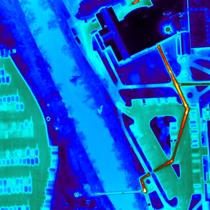
Aerial infrared image showing heat patterns along an underground steam distribution network

What an Aerial Steam Survey Delivers

Full-Network Thermal Mapping
Thermal anomalies associated with underground steam lines, laterals, manhole vaults, and building entries are mapped across the surveyed network and georeferenced for follow-up investigation.
Severity-Ranked Findings
AITscan ranks anomalies by thermal intensity so maintenance and engineering teams can prioritize verification, repairs, and capital work around operational impact and budget cycles.
Engineering-Ready Reporting
Reports combine mapped findings, thermal imagery, and location-specific documentation to support repair scoping, capital requests, distribution-system updates, and stakeholder reporting.

Aerial Steam Leak Detection for Complex Facilities

Universities & Colleges
AITscan helps universities identify suspected steam and condensate losses across campus networks.
School Systems
AITscan helps school systems identify suspected steam losses across district heating networks.
Correctional Facilities
AITscan helps correctional facilities evaluate suspected steam losses across secure campuses.
Cities & Municipalities
AITscan uses CityScan IR to identify suspected steam losses across municipal networks.

Why Use Aircraft for Steam Distribution Surveys?

Ground-based thermography can be useful for isolated manholes, exposed piping, or short sections of a steam system. For campuses, municipalities, correctional facilities, and other properties with underground distribution spread across a broad area, aircraft-based infrared surveys can provide a more complete view of the network within a coordinated inspection window.

AITscan can survey multiple miles of underground steam and condensate infrastructure while capturing thermal patterns across manholes, distribution corridors, laterals, and building connections. Collecting the system under similar environmental conditions can help create a more consistent dataset for comparing anomalies across different parts of the network.

This network-wide perspective is especially valuable when facility teams are trying to determine where follow-up investigation should begin. Rather than relying only on known trouble spots, complaints, or isolated ground inspections, aerial infrared data can help reveal suspected heat loss in areas that may not yet show obvious surface symptoms.

The resulting information gives engineering, maintenance, and capital-planning teams a stronger basis for prioritizing verification, scheduling repairs, updating utility records, and evaluating where future infrastructure investment may be needed.
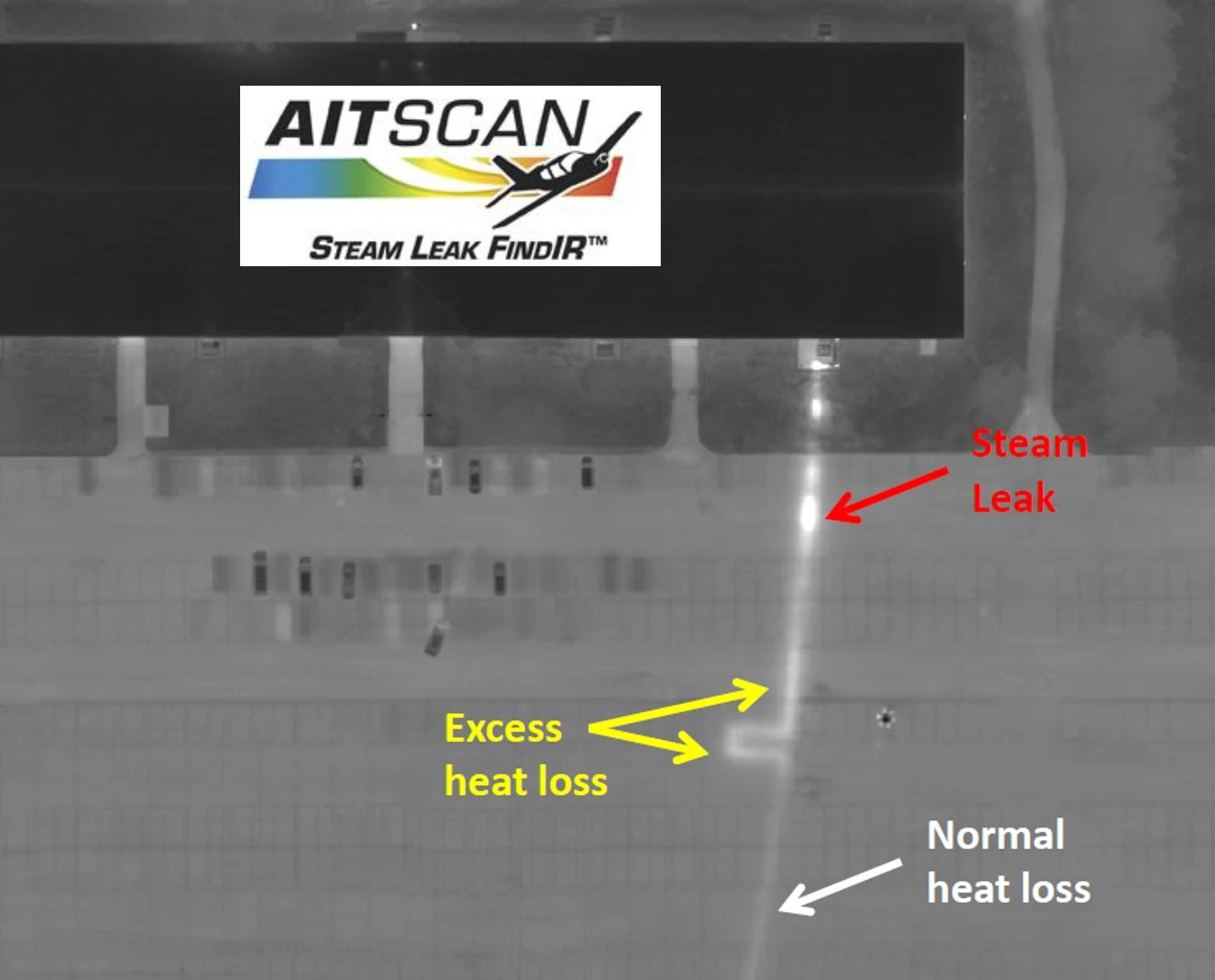
Infrared image showing a suspected underground steam leak and excess heat loss along a buried steam line

How an Aerial Steam Survey Works

01
Initial Conversation
A short call to review the network, service area, known problem areas, project goals, and the teams involved.
02
Technical Net Meeting
AITscan meets with facilities, engineering, and energy stakeholders to review the methodology, survey scope, and reporting requirements.
03
Scheduled Aerial Survey
The flight is scheduled around suitable thermal conditions, with flight planning and project coordination handled in advance.
04
Analysis & Reporting
Thermal imagery is processed, georeferenced, and analyzed, then delivered with ranked findings and location-specific documentation for follow-up investigation and repair planning.

The Cost of Undetected Steam Distribution Loss

Steam is one of the most energy-intensive utilities a facility can produce, and losses in an aging distribution network can become expensive quickly. The U.S. Department of Energy has documented significant distribution losses in older steam systems, and even a small number of failing segments can materially affect annual fuel costs.

Aerial infrared surveys help change the economics by giving facility teams a network-wide view of suspected heat loss. Instead of relying only on complaints, visible failures, or speculative excavation, AITscan provides ranked thermal findings that help teams focus verification and repairs where the potential impact is highest.

The financial value extends beyond fuel savings. Undetected underground steam failures can lead to emergency excavation, pavement restoration, lane closures, service interruptions, and unplanned labor. Identifying a developing problem before it becomes a major failure can turn an emergency response into scheduled maintenance.

Thermal data can also strengthen capital-planning decisions. When engineering teams need to justify replacing a section of distribution infrastructure, mapped thermal evidence can help support budget requests, repair scopes, and long-term system planning with more than anecdotal observations alone.

For many operators, the ROI of a steam survey comes from a combination of reduced energy loss, better repair prioritization, avoided emergency work, and improved capital planning. On extensive campus or municipal networks, identifying even one significant failure can represent a meaningful financial return on the inspection.

Frequently Asked Questions

Aircraft-mounted infrared sensors capture surface temperature differences above buried steam and condensate lines. Where heat is escaping from the distribution system, the ground above the affected area can appear warmer than surrounding soil. AITscan collects the thermal data during appropriate survey conditions, georeferences the findings, and maps suspected anomalies for follow-up investigation.
Ground-based and short-range platforms can work well for isolated manholes or short pipe segments. Aircraft are better suited for campuses, municipalities, and other distribution systems extending across miles because they can collect the network within a coordinated thermal window and create a more consistent dataset across the surveyed area.
Accuracy depends on survey conditions, system characteristics, sensor selection, and experienced interpretation. When these factors are properly controlled, aerial infrared can identify thermal anomalies associated with suspected steam and condensate losses and help teams determine where ground verification should be concentrated before excavation or repair.
A typical university campus or correctional facility may be surveyed during a single overnight flight, while larger municipal networks may require additional flight windows depending on geography, weather, and system size. Reporting timelines vary by project scope and the amount of data collected.
Aerial surveys are particularly useful for universities, school systems, correctional facilities, municipalities, military installations, and other properties with extensive underground steam or condensate infrastructure. Smaller systems with only short runs of buried piping may be better suited to localized inspection methods.
AITscan reports can include network-wide maps, thermal imagery, georeferenced anomalies, severity rankings, and location-specific documentation to support verification, repair scoping, capital requests, and updates to utility or distribution drawings.

Ready to Evaluate Your Steam Distribution Network?

Talk with AITscan about your underground steam or condensate system, survey area, and project goals to determine whether an aerial infrared survey is a good fit.