Landfill Thermal Inspection

Landfill Fire Detection & Methane Surveys By Aerial Inspection

AITscan uses aircraft-based infrared surveys to identify subsurface combustion, thermal hotspots, and methane anomalies across active and closed landfill sites.

37+ Years

Of Infrared Expertise

50 States

Plus Alaska & Puerto Rico

Aircraft

Not Drones

Engineered

For Facility Decision-Makers

What Is Aerial Landfill Fire & Methane Detection?

Landfill fire detection uses aircraft-mounted infrared sensors to identify abnormal heat patterns associated with subsurface combustion, smoldering waste, and other elevated thermal conditions across active and closed landfill sites. These anomalies can be difficult to identify from the ground when heat is developing below the surface.

AITscan collects and georeferences thermal imagery across the landfill footprint so operators, engineers, and environmental teams can focus follow-up investigation on suspected hotspots. The same aerial survey can also help identify thermal patterns that may be associated with methane migration or gas-collection system performance when evaluated alongside site conditions and existing monitoring data.

The resulting dataset can support landfill operations, safety planning, GCCS review, post-closure monitoring, and regulatory documentation. For broader environmental or municipal infrastructure needs, AITscan also provides pollution and sewer leak detection using aircraft-based infrared surveys.
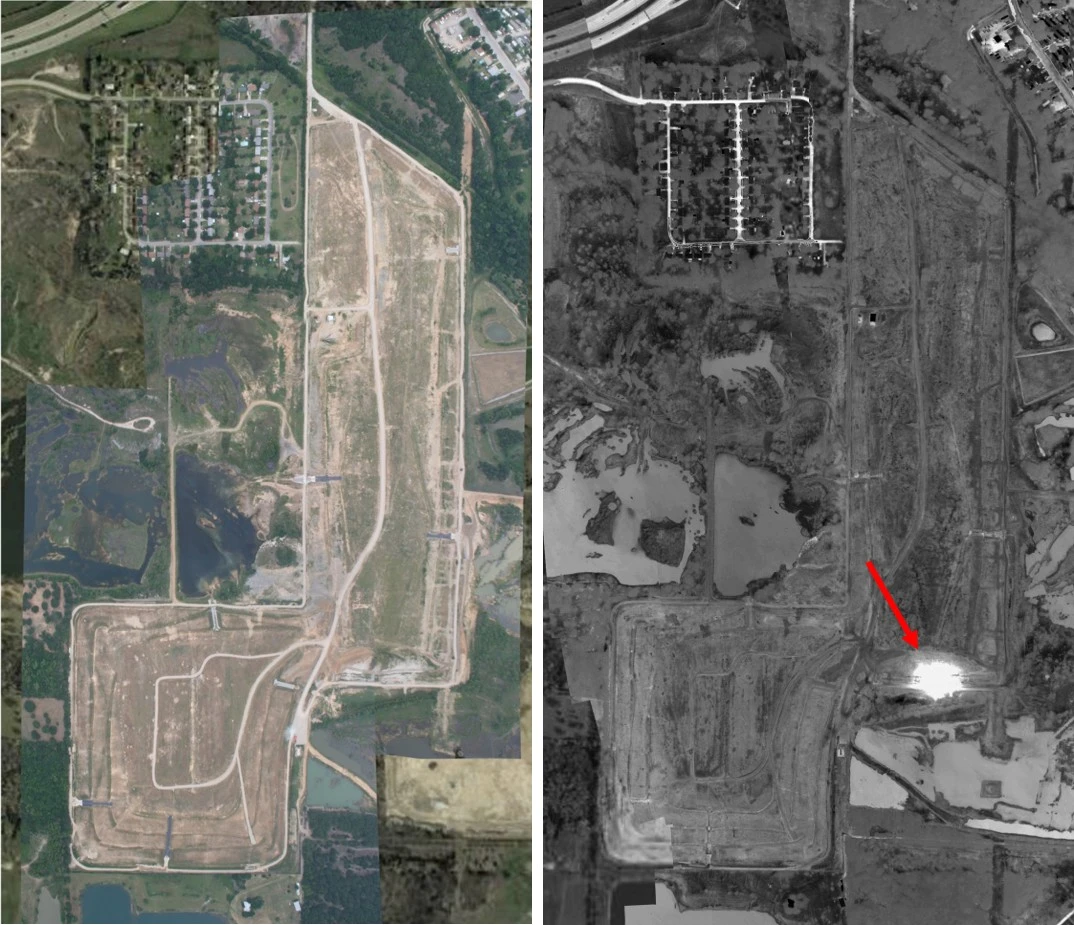
Landfill fire detection showing a major thermal hotspot across a municipal solid waste site

What a Landfill Fire Detection Survey Delivers

Subsurface Combustion Detection
AITscan maps elevated thermal zones associated with smoldering, oxidation, or active subsurface combustion across the landfill footprint.
Methane Anomaly Mapping
Thermal and gas-related anomalies are georeferenced to help operators investigate suspected methane migration and GCCS performance.
Compliance & Stewardship Documentation
Reports support air-quality programs, operational review, regulatory reporting, and long-term post-closure monitoring.

Built for Active and Closed Landfill Sites

Municipal Solid Waste Operators
AITscan helps municipal landfill operators use landfill fire detection to identify subsurface heat and combustion anomalies.
Private Landfill Operators
AITscan supports private landfill operators with aerial thermal surveys for combustion, methane, and compliance monitoring.
Post-Closure Stewards
AITscan helps post-closure programs monitor thermal anomalies across capped and legacy landfill sites.
Environmental Consultants
AITscan provides mapped thermal data that supports landfill investigations, engineering review, and compliance planning.

Why Use Aircraft for Landfill Fire Detection?

Ground-based thermography and short-range platforms can be useful for a known cell, exposed area, or isolated hotspot. For active landfills, closed sites, and multi-site portfolios, aircraft-based landfill fire detection can provide broader thermal coverage while keeping personnel away from areas where subsurface combustion or gas hazards may be present.

AITscan can collect the full landfill footprint within a coordinated flight window, helping create a consistent thermal dataset across working cells, capped areas, slopes, perimeter zones, and gas-collection infrastructure. That consistency makes it easier to compare thermal anomalies across the site and determine which areas warrant closer investigation.

Aircraft-based collection is also valuable because suspected subsurface combustion may develop before obvious surface smoke or visible distress appears. A site-wide thermal survey can help operators identify elevated-temperature zones earlier and focus ground verification where the strongest anomalies are present.

For operations, compliance, and environmental teams, the value goes beyond coverage. Georeferenced thermal findings can support combustion-response planning, GCCS review, post-closure stewardship, and regulatory documentation while reducing the need to send personnel across every part of the site during the initial inspection.
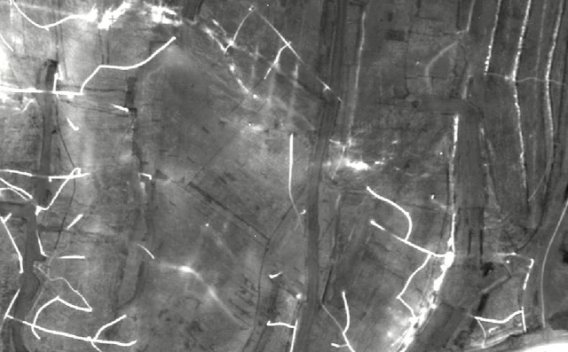
Aerial infrared image showing multiple thermal anomalies and heat patterns across a landfill surface

How a Landfill Survey Works

01
Initial Conversation
A short call to review site status, footprint, GCCS layout, known concerns, and the operations, compliance, and engineering teams involved.
02
Net Meeting
AITscan reviews the survey methodology, deliverables, site drawings, and how the findings will support combustion and methane monitoring.
03
Scheduled Aerial Survey Flight
The flight is scheduled for suitable thermal conditions, with FAA coordination and site planning handled in advance.
04
Site Anomaly Report
Thermal imagery is processed, georeferenced, and ranked, then delivered with mapped findings for investigation, GCCS review, and compliance planning.

The Cost of Undetected Landfill Combustion

Subsurface combustion can escalate quickly when it is discovered late. A small oxidation event can develop into a prolonged response involving engineered intervention, regulator coordination, gas-collection adjustments, and significant operational disruption. Landfill fire detection helps operators identify elevated thermal zones before visible smoke or obvious surface distress becomes the first warning sign.

The financial impact is not limited to the combustion response itself. Operators may face additional costs tied to equipment mobilization, excavation, GCCS modifications, compliance reporting, monitoring, and extended site management. Earlier identification gives operations and engineering teams more time to investigate suspected hotspots and plan a controlled response.

Methane-related anomalies can create a second layer of risk. Changes outside the expected gas-collection footprint may trigger additional investigation, reporting, or capital work, particularly where Title V, Subpart Cf, or state air-quality requirements apply. A site-wide thermal dataset can provide stronger documentation for reviewing those conditions alongside existing GCCS and monitoring data.

Regular aerial surveys can also create a longitudinal record of the landfill’s thermal condition. That history can help operators compare recurring anomalies, evaluate changes after GCCS expansion or corrective work, support post-closure stewardship, and demonstrate an active monitoring program when regulators or other stakeholders request documentation.

For sites where leachate, stormwater, or receiving-water concerns overlap with landfill operations, AITscan also provides pollution and sewer leak detection using aircraft-based infrared surveys.

Frequently Asked Questions

Subsurface oxidation and combustion can warm the waste mass and the surface above it before visible smoke appears. Aircraft-mounted thermal sensors map those elevated-temperature zones across the site so AITscan can identify suspected hotspots for follow-up investigation.
Aerial thermal data can help identify anomalies that may be associated with gas migration outside the expected GCCS footprint. When paired with appropriate methane-specific sensing and site data, the findings can support Title V, Subpart Cf, state air-program, and compliance workflows.
Aircraft are well suited for full-site and multi-site landfill fire detection because they can capture the entire footprint within a coordinated thermal window while keeping ground personnel away from potential combustion and gas hazards.
A typical municipal solid waste site can often be scanned within a single flight window, while multi-site portfolios may require several flight days depending on geography and weather. Initial ranked findings are generally delivered within two to four weeks.
Yes. The aircraft operates at altitude and does not require ground access, so haul roads, the working face, leachate systems, gas collection, and other normal landfill operations can continue during the survey.
Many active landfill operators may benefit from aerial thermal surveys every one to three years, with more frequent inspections considered for sites with known combustion history, recent GCCS changes, or increased regulatory attention. Closed sites may transition to a longer cadence based on their post-closure stewardship plans.

Ready to Evaluate Your Landfill Site?

Talk with AITscan about your landfill, thermal concerns, methane monitoring, and compliance goals to see whether landfill fire detection is a good fit.